


| March 14 2024 |
Central Rockies Major Winter Storm: (3/13/24 - 3/15/24)
By: Frank Pereira, WPC Meteorologist
Meteorological Overview:
A significant winter storm impacted portions of the central Rockies from Wednesday, March 13, to Friday, March 15. The storm produced substantial snowfall, primarily affecting the Front Range region and the foothills west of Denver. Additionally, it generated powerful, gusty winds across Colorado, Wyoming, and Utah.
The storm's development began with an upper-level trough that entered and traversed the Pacific Northwest on Tuesday, March 12. The upper air analysis from early Wednesday, March 13, revealed a broad trough moving from the Intermountain West into the Rockies, with a closed low forming over northern Idaho and western Montana. The analysis also indicated a weak shortwave trough ejecting east through the central Rockies and an upper-level jet couplet centered over Colorado. In response to this favorable forcing aloft, surface analyses from March 13 showed low pressure developing over eastern Colorado. This system became a focus for an anomalous moisture pool that remained in place even as the system moved east.
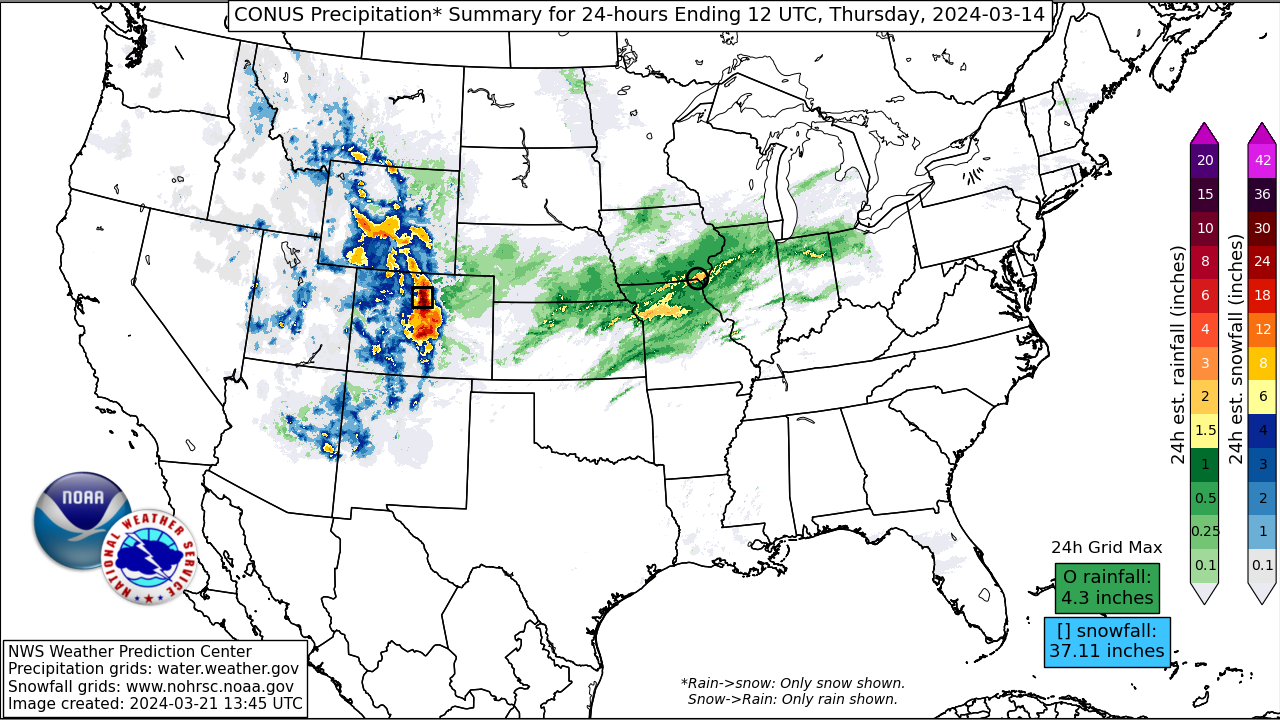
The upper air analysis from late Wednesday showed the upper low sinking south into the Great Basin. Surface low pressure that developed earlier over eastern Colorado began to track east through the central Plains. North of the trailing cold front, deep easterly flow through the mid-levels extended back through the central Rockies, fortifying the moist air mass over eastern Colorado while driving it farther west into the favored upslope terrain and an area of low-to-mid level ascent. By late Wednesday, observations indicated widespread rain, with embedded thunderstorms, along much of the Wyoming and Colorado foothills and snow further west in the higher terrain. As the evening progressed, cold air advection and increasing precipitation rates supported the rain-snow transition line shifting farther east, with heavy wet snow reported across much of the Denver-Boulder metropolitan areas by the late evening. Snowfall rates increased to 1-2 inches/hour across much of the Denver-Boulder region, with observers reporting rates up to 3 inches/hour in the foothills.
The upper low continued to settle south Wednesday night, reaching the lower Colorado River Basin by early Thursday, March 14. Meanwhile, the surface-to-mid level wave in the central U.S. tracked east, moving into the mid-Mississippi Valley Thursday morning. A long fetch of post-frontal northeasterly flow continued supporting precipitation from the High Plains into the Rockies, including precipitation spreading south into southeastern Colorado overnight. This precipitation persisted into Thursday, with periods of moderate to heavy snow reported in the Colorado Springs and Pueblo areas. Strong winds developed across northern Utah, with powerful gusts recorded along the Wasatch Front and other areas prone to strong downsloping. Periods of snow, sometimes moderate to heavy, continued across the central Rockies through Thursday as low-to-mid-level easterly flow prevailed. On Friday, snow began to taper off as the winds weakened.
Impacts:
The storm produced many notable impacts along the Colorado Front Range and the surrounding areas, including the Denver metropolitan area. This storm was one of the largest in recent years, comparable to the Pi Day Storm in 2021 and the historic storm of March 2003. It resulted in heavy snowfall, road closures, and widespread disruptions. Some of the heaviest snow totals were reported in Gilpin County, including 61.5 inches in Aspen Springs, while several locations in neighboring Boulder and Jefferson counties reported between 3-4 feet. The Denver metropolitan area received 10-20 inches of snowfall. Numerous road closures occurred, including over a 50-mile stretch of Interstate 70 west of Denver. Many vehicles were stranded, and travel became impossible on unplowed roads, even for high-clearance or four-wheel-drive vehicles. Denver International Airport experienced over 800 flight cancellations, with more than 400 additional delays. The storm led to widespread school closures and significant disruptions to daily life. Tree limbs snapped under the weight of the heavy snow, causing damage and power outages to more than 100,000 customers in Colorado. Residents in some areas were trapped in their homes for days due to impassable roads. While the heavy snowfall benefited ski resorts, avalanche risks forced some to shut down temporarily.
The storm also produced heavy snow across south-central and southeastern Wyoming, including reports of more than 3 feet west of Laramie. Hundreds of miles of Wyoming interstates and highways were closed for several hours, including a 250-mile stretch of Interstate 80 west of Cheyenne. Farther south, observers reported storm totals of 1-2 feet in the Colorado Springs area and amounts over 3 feet in the southern Front Range. On March 14, Colorado Springs recorded a record daily max snowfall of 10.2 inches.
This event produced a very heavy, wet snowfall that contained a significant amount of liquid (equivalent) precipitation for many areas. Pueblo set a March daily precipitation record with 1.53 inches reported on March 14. Liquid equivalents farther to the north totaled more than 3 inches in the Denver-Boulder areas, accounting for 15-20 percent of their typical annual precipitation. Strong wind gusts were reported across portions of the central Rockies, including gusts over 70 mph in northern Utah, along the Wasatch Front north of Salt Lake City, and in the Ogden area. Despite these powerful winds, the storm produced minimal damage across northern Utah.