| WPC Met Watch |
|
|
Mesoscale Precipitation Discussion: #0538 |
|
(Issued at 305 AM EDT Tue Jul 02 2024
) |
|
| MPD Selection |
|
|
|
|
|

Mesoscale Precipitation Discussion 0538
NWS Weather Prediction Center College Park MD
305 AM EDT Tue Jul 02 2024

Areas affected...southwest IA...southeast NE...adjacent portions
of far northwest MO

Concerning...Heavy rainfall...Flash flooding likely

Valid 020705Z - 021200Z

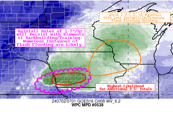
Summary...Rainfall rates of 1-2"/hr will persist with elements of
backbuilding/training supporting additional localized totals of
2-5". Numerous instances of flash flooding are likely.

Discussion...A large, disjointed mesoscale convective system (MCS)
continues to bring heavy rainfall to portions of the Upper Midwest
and Central Plains late tonight. While the primary area of
thunderstorms (and resulting significant flash flooding) has
occurred along the I-80 corridor in southeast NE, a secondary area
of storms has also manifested farther northeast (over northeast
IA, southeast MN, and adjacent portions of WI). All of this
activity (with a large area of stratiform precipitation in
between) is being driven by a strong low-level jet (LLJ) ushering
in warm air advection/moisture transport and subsequent
destabilization (with 3-hr MU CAPE increases of 400-1000 J/kg)
across a broad area from the Southern/Central Plains to the Upper
Midwest. The strongest convection (being rooted closer to the
surface) continues to trail behind in southeast NE and southwest
IA, and recent backbuilding to the west (towards the most Theta E
rich air at the surface) has resulted in repeating of 1-2"/hr
rainfall rates (with MRMS estimating localized totals of 2-4" over
a 2-3 hour period in the vicinity of the Lincoln and Omaha metro
areas). This is in stark contrast to the aforementioned secondary
area of heavy rainfall farther northeast, which remains quite
progressive with hourly rates capped closer to 1.5" (and
importantly without training/backbuilding elements).

Going forward, hi-res guidance is actually in better spatial
agreement (per HREF ensemble agreement scale, EAS, neighborhood
probability fields) with the secondary area of heavy rainfall,
suggesting higher confidence in 1-2" accumulations in this area.
That said, when focusing on higher-end amounts (additional
accumulations of 3"+), the 40-km neighborhood exceedance
probabilities are much higher (20-40%) along and downstream of the
hard hit Lincoln/Omaha metro areas. The 00z HREF probability
matched mean QPF depicts 2-5" totals in this region (primarily in
southwest IA going forward), and this is driven by the ARW,
ARW2/NSSL, and HRRR members (with subsequent runs of the HRRR
remaining fairly consistent with 2-5" depictions through 12z,
though notably too far north). Given the observational trends,
consistent model guidance, and impressive parameter space (MU CAPE
1000-2000 J/kg, PWATs 1.8-2.2", and effective bulk shear of 30-50
kts) in this region, numerous instances of flash flooding are
likely (and will likely continue in already hard-hit areas).

Churchill

ATTN...WFO...DMX...EAX...GID...OAX...

ATTN...RFC...MBRFC...NCRFC...NWC...

LAT...LON   41959347 40939349 40279591 40769746 41679621
Download in GIS format: Shapefile
| KML
Last Updated: 305 AM EDT Tue Jul 02 2024
|


