Alaska Extended Forecast Discussion
NWS Weather Prediction Center College Park MD
639 PM EDT Wed Jul 03 2024
Valid 12Z Sun Jul 07 2024 - 12Z Thu Jul 11 2024
...Overview and Guidance Evaluation/Preferences...
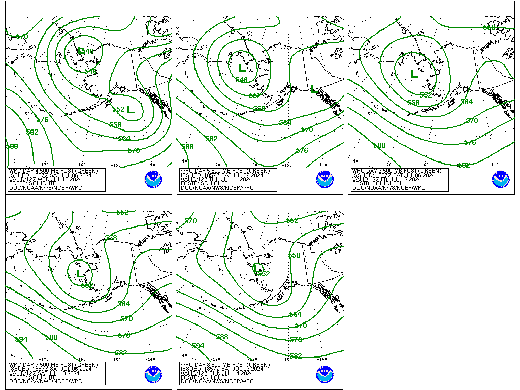
Guidance solutions are well clustered valid Sunday-Tuesday in a
pattern with above average predictability. Prefer a composite of
the 12 UTC GFS/ECMWF/UKMET/Canadian for detail. Gradually switched
preference to a model and ensemble blend through longer time
frames, increasing emphasis to the more compatible ensemble means
over time amid growing forecast spread and uncertainty.
...Weather/Hazards Highlights...
A wavy and weakening surface front tracking west to east and then
settling across Mainland Alaska should provide focus for some
moderate to locally heavier precipitation, with higher totals
likely associated with higher terrain given favorable upper
support this weekend into early next week. Much of Alaska remains
generally wet and unsettled overall the entire period, which
should help bring some relief to the spreading wildfires across
the state currently. By this weekend, rain and storms will
increase in coverage and intensity from the Alaska Peninsula to
Southern Coast as Gulf moisture gets pulled northward ahead of the
northern stream upper troughing/system progression over the
mainland. Given overall upper troughing over the state into next
week, daytime highs across nearly all of Mainland Alaska will be
well below normal, with the greatest anomalies across western and
northern parts of the state. Temperatures may begin to moderate
again by mid next week. By then there is also a growing guidance
signal to lift an organized low pressure/frontal system up across
the Gulf of Alaska. This slow/evolving track would provide
protracted unsettled maritimes conditions over the Gulf and act to
increasingly through next week support potential for some moderate
to heavy rainfall from southern Alaska through the Southeast.
Schichtel
Additional 3-7 Day Hazard Information can be found on the WPC
medium range hazards outlook chart at:
https://www.wpc.ncep.noaa.gov/threats/threats.php
WPC medium range Alaskan products including 500mb, surface
fronts/pressures progs and sensible weather grids can also be
found at:
https://www.wpc.ncep.noaa.gov/alaska/ak_5dayfcst500_wbg.gif
https://www.wpc.ncep.noaa.gov/alaska/akmedr.shtml
https://www.wpc.ncep.noaa.gov/alaska/ak_5km_gridsbody.html


